- Odzież / Ochraniacze
- Kaski
- Odzież motocyklowa
- Ochraniacze
- Fox Rowerówka
- Gogle
- Odzież codzienna
- Leatt rowerówka
- Części
- Oleje / Smary / Pielęgnacja / Chemia
- Silnik i osprzęt
- Cylindry
- Rozrząd
- Uszczelki Silnika
- Tłoki - komplety
- Tarcze Sprzęgłowe
- Starter / Sprężyny startera
- Dekle / pokrywy silnika
- Płytki Zaworowe
- Głowice
- Uszczelniacze silnika
- Bębny Sprzęgła / Dzwony
- Sprzęgła Odśrodkowe / Szczęki
- Sprężyny sprzęgła
- Przekładki sprzegła
- Wały Korbowe / Korbowody / Łożyska
- Kosze sprzęgłowe
- skrzynie biegów / Koła zebate
- Łożyska skrzyni biegów
- Zawory
- Sprężyny Zaworowe
- Śruby / Korki
- Silniki kompletne
- Układ elektryczny / Zapłon
- Regulatory napięcia
- Alternatory-Statory
- Moduły zapłonu
- Akumulatory
- Przewody wysokiego napięcia
- Ładowarki do akumulatorów
- Cewki zapłonowe, świetlne, ładowania
- Kondensatory zapłonowe
- Klakson
- Świece zapłonowe
- Fajki zapłonowe
- Czujniki, właczniki
- Liczniki/komputery pokładowe
- Przełączniki, właczniki
- końcówki elektryczne, wtyczki, kostki
- Stacyjki / Kluczyki
- Przerywacze kierunkowskazów
- rozrusznik/ przekaźniki/ zestawy naprawcze
- Plastiki Cross
- Zawieszenie
- Lampy / Kierunkowskazy
- Nadwozie
- Dźwignie Sprzęgła
- Dźwignie Hamulca
- Kierownice Akcesoria
- Podnóżki
- Linki i cięgna
- Lusterka
- Mocowania Uchwyty Dźwigni sprzęgła CROSS
- Manetki
- Osłony Nadwozia
- Hand bary - osłony dłoni
- Końcówki Kierownicy / Cieżarki
- Dźwignie Zmiany Biegów
- Sprzęgła hydrauliczne / pompy / zestawy
- Dźwignia rozrusznika / Kopniak / Kopajka
- Mocowania Tablicy Rejestracyjnej
- Dźwignie Sportowe
- Szyby motocyklowe
- Naklejki na motocykl
- Okleiny plastików CROSS / OFF-ROAD
- Sety
- Zegary, obudowy zegarów
- Koła, piasty, obręcze
- Owiewki
- Pokrowce na siedzenia, gąbki, siedzenia
- Ramy motocyklowe
- błotniki
- Filtry
- Układ hamulcowy
- Stelaże przednie
- Opony/Dętki/Felgi
- Układ napedowy
- Układ paliwowy
- Układ Wydechowy
- Układ chłodzenia
- Układ rozruchowy

- Akcesoria
- Na Prezent
- Narzędzia
- Bagaż
- Blokady, zabezpieczenia
- Pokrowce na motocykl / quada
- Inne akcesoria
- Tank Pady
- Zestawy naprawcze opon i dętek
- Stojaki, podnośniki
- Intercomy - komunikacja / łączność
- Kamery
- telefony / uchwyty, pokrowce
- Baterie - POWERBANK
- Naklejki
- Kamizelki Odblaskowe
- Ładowarki / Zapalniczki
- Podnóżki / Stopki Centralne
- Liczniki Motogodzin
- Śrubki do owiewek
- Rolki serwisowe
- Opaski zaciskowe
- Lampki rowerowe
- Artykuły
- Motocykle
- Odzież / Ochraniacze
- Kaski
- Odzież motocyklowa
- Ochraniacze
- Fox Rowerówka
- Gogle
- Odzież codzienna
- Leatt rowerówka
- Części
- Oleje / Smary / Pielęgnacja / Chemia
- Silnik i osprzęt
- Cylindry
- Rozrząd
- Uszczelki Silnika
- Tłoki - komplety
- Tarcze Sprzęgłowe
- Starter / Sprężyny startera
- Dekle / pokrywy silnika
- Płytki Zaworowe
- Głowice
- Uszczelniacze silnika
- Bębny Sprzęgła / Dzwony
- Sprzęgła Odśrodkowe / Szczęki
- Sprężyny sprzęgła
- Przekładki sprzegła
- Wały Korbowe / Korbowody / Łożyska
- Kosze sprzęgłowe
- skrzynie biegów / Koła zebate
- Łożyska skrzyni biegów
- Zawory
- Sprężyny Zaworowe
- Śruby / Korki
- Silniki kompletne
- Układ elektryczny / Zapłon
- Regulatory napięcia
- Alternatory-Statory
- Moduły zapłonu
- Akumulatory
- Przewody wysokiego napięcia
- Ładowarki do akumulatorów
- Cewki zapłonowe, świetlne, ładowania
- Kondensatory zapłonowe
- Klakson
- Świece zapłonowe
- Fajki zapłonowe
- Czujniki, właczniki
- Liczniki/komputery pokładowe
- Przełączniki, właczniki
- końcówki elektryczne, wtyczki, kostki
- Stacyjki / Kluczyki
- Przerywacze kierunkowskazów
- rozrusznik/ przekaźniki/ zestawy naprawcze
- Plastiki Cross
- Zawieszenie
- Lampy / Kierunkowskazy
- Nadwozie
- Dźwignie Sprzęgła
- Dźwignie Hamulca
- Kierownice Akcesoria
- Podnóżki
- Linki i cięgna
- Lusterka
- Mocowania Uchwyty Dźwigni sprzęgła CROSS
- Manetki
- Osłony Nadwozia
- Hand bary - osłony dłoni
- Końcówki Kierownicy / Cieżarki
- Dźwignie Zmiany Biegów
- Sprzęgła hydrauliczne / pompy / zestawy
- Dźwignia rozrusznika / Kopniak / Kopajka
- Mocowania Tablicy Rejestracyjnej
- Dźwignie Sportowe
- Szyby motocyklowe
- Naklejki na motocykl
- Okleiny plastików CROSS / OFF-ROAD
- Sety
- Zegary, obudowy zegarów
- Koła, piasty, obręcze
- Owiewki
- Pokrowce na siedzenia, gąbki, siedzenia
- Ramy motocyklowe
- błotniki
- Filtry
- Układ hamulcowy
- Stelaże przednie
- Opony/Dętki/Felgi
- Układ napedowy
- Układ paliwowy
- Układ Wydechowy
- Układ chłodzenia
- Układ rozruchowy
- Akcesoria
- Na Prezent
- Narzędzia
- Bagaż
- Blokady, zabezpieczenia
- Pokrowce na motocykl / quada
- Inne akcesoria
- Tank Pady
- Zestawy naprawcze opon i dętek
- Stojaki, podnośniki
- Intercomy - komunikacja / łączność
- Kamery
- telefony / uchwyty, pokrowce
- Baterie - POWERBANK
- Naklejki
- Kamizelki Odblaskowe
- Ładowarki / Zapalniczki
- Podnóżki / Stopki Centralne
- Liczniki Motogodzin
- Śrubki do owiewek
- Rolki serwisowe
- Opaski zaciskowe
- Lampki rowerowe
- Artykuły
- Motocykle


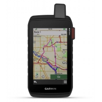
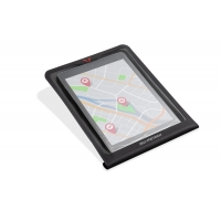
GARMIN Montana® 710i
010-02964-01
New
This product is no longer in stock
Data sheet
| BATERIA | rodzaj: litowo-jonowa |
| INTERFEJS | Obsługa szybkiego USB-C i NMEA 0183 |
| OGÓLNE | MIL-STD-810 - na temperatury, wstrząsy, wodę |
| CZUJNIKI | Bardzo czuły odbiornik |
| FUNKCJE DLA ZAJĘĆ NA POWIETRZU | Nawigacja od punktu do punktu |
| WYMIARY NAWIGACJI | szerokość: 6,48cm |
| WYŚWIETLACZ | Ekran dotykowy |
| PAMIĘĆ | wewnętrzna: 32 GB |
| MAPY | Fabrycznie załadowane mapy |
| FUNKCJE TELEFONICZNE PRZYDATNE NA CO DZIEŃ | Aplikacja CONNECT IQ™ (tarcze zegarka, pola danych, widżety i aplikacje) |
| FUNKCJE BEZPIECZEŃSTWA I MONITOROWANIA | Aplikacja LIVETRACK |
| FUNKCJE INREACH | Interaktywna funkcja sos |
More info
STAY ON TRACK AND IN TOUCH THROUGH ALL KINDS OF ADVENTURES
Get advanced outdoor features — plus inReach technology for two-way messaging and interactive SOS alerts1 — in a rugged 5-inch format that’s ideal for navigation on foot, bike, kayak, ATV and more.
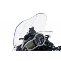
LARGE 5-INCH GLOVE-FRIENDLY TOUCHSCREEN
PRELOADED ROUTABLE TOPOGRAPHIC MAPS WITH LANDMARKS
STAY IN TOUCH WITH INREACH MESSAGING AND 24/7 SOS1
MEETS MIL-STD 810 FOR THERMAL, SHOCK, WATER AND VIBRATION
SATELLITE IMAGERY SHOWS VIVID OVERHEAD VIEWS OF YOUR ROUTE
SUPPORTS OUTDOOR MAPS+ FOR PREMIUM MAPPING (SOLD SEPARATELY)
WHAT YOU'LL LOVE
GLOBAL CONNECTIVITY
With an active inReach subscription, you can stay connected even when your adventures go off grid. Instead of relying on smartphone coverage, now your messages, SOS and tracking are transferred via the 100% global Iridium® satellite network1.
RUGGED BY DESIGN
This durable, water-resistant handheld is tested to meet MIL-STD 810 for thermal, shock, water and vibration. It features a glove-friendly 5-inch touchscreen and is compatible with a variety of robust mounting solutions (sold separately) to best suit your activities.
TOPOACTIVE MAPS
To navigate your adventures, use preloaded topographical maps. View terrain contours, elevations, coastlines, rivers, landmarks and more.
SATELLITE VIEWS
Access subscription-free, high-resolution satellite imagery with direct-to-device downloads over Wi-Fi® connectivity. See photorealistic overhead views of routes and surrounding terrain, and easily create waypoints based on landmarks.
OUTDOOR MAPS+
Add a subscription to Outdoor Maps+ (sold separately), and get ongoing access to a wide variety of premium mapping content and regular updates sent right to your Garmin device via Wi-Fi technology.
GARMIN EXPLORE™ APP
Pair with the Garmin Explore app to plan and review trip data, plus manage your waypoints, courses and activities.
EXPLORE THE WORLD. STAY CONNECTED TO HOME.
INREACH FEATURES
TWO-WAY MESSAGING
Exchange text messages with loved ones back home, or communicate via inReach device to inReach device in the field1.
INTERACTIVE SOS
In case of emergency, trigger an interactive SOS message to Garmin Response℠, a 24/7-staffed professional emergency response coordination centre1.
INREACH WEATHER
Available inReach weather forecast service provides detailed updates directly to your Montana handheld or paired devices, so you’ll know what to expect en route1.
Live Tracking
Using your live tracking page, followers can see your progress, ping your device to see your GPS location and exchange messages during your trip1.
NAVIGATION FEATURES
MULTI-GNSS SUPPORT
Access to GPS and Galileo satellite networks enables Montana 710i to track in more challenging environments than GPS alone.
ABC SENSORS
Navigate your next trail with ABC sensors, including an altimeter for elevation data, barometer to monitor weather and 3-axis electronic compass.
CITY NAVIGATOR® MAPS
Seamlessly transition from trails to road navigation with preloaded European City Navigator street mapping, which guides your drive with easy-to-follow turn-by-turn directions.
ADDITIONAL MAPS
With 32 GB of onboard memory, you can download even more maps, such as BlueChart® g3 charts for the water (sold separately).
ACTIVE WEATHER
Access up-to-date active weather forecasts via the Garmin Connect™ app on your compatible smartphone
DOG TRACKING
For hunters and trainers, this Montana handheld syncs with your compatible Astro® or Alpha® series handhelds to help track sporting dogs in the field.
WIKILOC TRAILS
This preloaded app lets you easily download hiking, cycling and other Wikiloc trails shared by outdoor enthusiasts like you. Get a free 60-day Wikiloc Premium trial to try this and other exclusive features.
ADVENTURE FEATURES
EXPEDITION MODE
Trek far and wide off-grid. Use expedition mode, an ultralow-powered GPS reference, to keep Montana tracking for more than 2 weeks between recharges.
BATTERY OPTIONS
An internal lithium-ion battery pack provides up to 24 hours of battery life in GPS mode and recharges with a standard USB-C® cable.
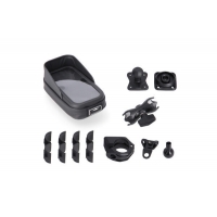
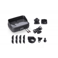
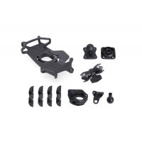
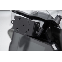
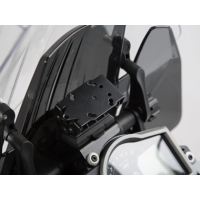
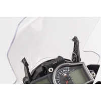
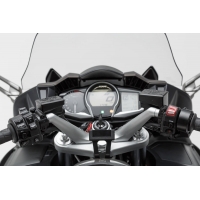
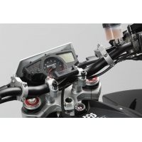
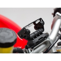
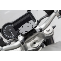
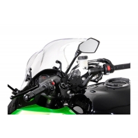
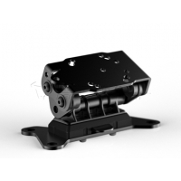
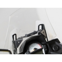
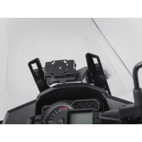
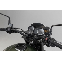
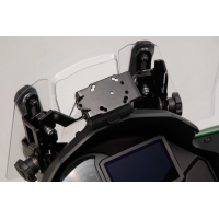
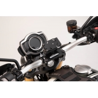
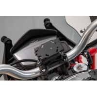
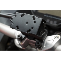
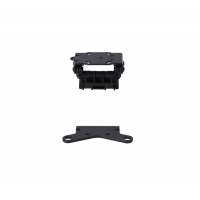
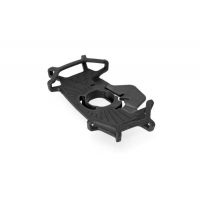
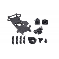
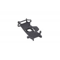
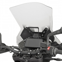
VEHICLE MOUNTS
A variety of Montana handheld-compatible mounts (sold separately) lets you adapt your navigator for use on ATVs, boats, cars, motorcycles, motorhomes or other vehicles.
1 Active satellite subscription required. Some jurisdictions regulate or prohibit the use of satellite communication devices. It is the responsibility of the user to know and follow all applicable laws in the jurisdictions where the device is intended to be used.
Wi-Fi is a registered trademark of the Wi-Fi Alliance. USB-C is a registered trademark of USB Implementers Forum.
Engineering enhancements are ongoing and may not be reflected in the pictures, videos and specifications.
other products in the same category: (30)
-
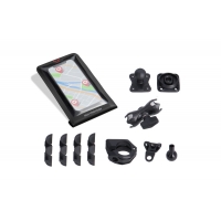
UNIWERSALNY ZESTAW RÓŻNYCH UCHWYTÓW GPS Z POKROWCEM NA...
-
UNIWERSALNY ZESTAW RÓŻNYCH UCHWYTÓW GPS Z POKROWCEM NA...
-
UNIWERSALNY ZESTAW RÓŻNYCH UCHWYTÓW GPS Z UCHWYTEM T-LOCK...
-
ZESTAW UCHWYTÓW GPS NA KIEROWNICĘ WRAZ Z POKROWCEM NA...
-
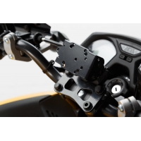
MOCOWANIE GPS NA KIEROWNICĘ SW-MOTECH BMW/HONDA/SUZUKI...
-
MOCOWANIE GPS NA POPRZECZKĘ SW-MOTECH 10/12MM BLACK
-
MOCOWANIE GPS NA POPRZECZKĘ SW-MOTECH 13/16MM BLACK
-
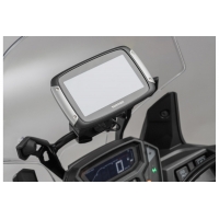
MOCOWANIE GPS DO KOKPITU SW-MOTECH KTM 790/890 ADV....
-
MOCOWANIE GPS DO KOKPITU SW-MOTECH KTM 1290 SUPER...
-
MOCOWANIE GPS DO KOKPITU SW-MOTECH KTM 1050/1090/1190...
-
MOCOWANIE GPS NA KIEROWNICĘ SW-MOTECH YAMAHA FJR 1300...
-
UCHWYT GPS ANTYWIBRACYJNY SW-MOTECH BLACK
-
MOCOWANIE GPS NA KIEROWNICĘ SW-MOTECH BMW MODELS BLACK
-
MOCOWANIE GPS NA KIEROWNICĘ SW-MOTECH BMW/TRIUMPH MODELS...
-
MOCOWANIE GPS NA KIEROWNICĘ SW-MOTECH KAWASAKI Z 1000 SX...
-
MOCOWANIE GPS NA KIEROWNICĘ SW-MOTECH KAWASAKI GTR 1400...
-
MOCOWANIE GPS DO KOKPITU SW-MOTECH KAWASAKI VERSYS 650...
-
MOCOWANIE GPS DO KOKPITU SW-MOTECH KAWASAKI VERSYS 1000...
-
MOCOWANIE GPS DO KOKPITU SW-MOTECH KAWASAKI...
-
MOCOWANIE GPS DO KOKPITU SW-MOTECH KAWASAKI VERSYS 1000...
-
MOCOWANIE GPS NA KIEROWNICĘ SW-MOTECH...
-
MOCOWANIE GPS DO KOKPITU SW-MOTECH TRIUMPH TIGER 800/800...
-
MOCOWANIE GPS NA KIEROWNICĘ SW-MOTECH MOTO GUZZI V85 TT...
-
MOCOWANIE GPS NA KIEROWNICĘ SW-MOTECH DUCATI MULTISTRADA...
-
MOCOWANIE GPS NA KIEROWNICĘ SW-MOTECH DUCATI MULTISTRADA...
-
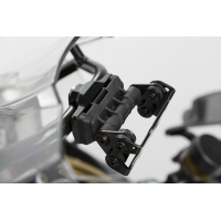
UCHWYT T-LOCK DO MOCOWANIA SMARTFONA MAŁY SW-MOTECH WITH...
-
POKROWIEC NA TABLET DO TANKBAGU PRO SW-MOTECH MOLLE...
-
UNIWERSALNY ZESTAW RÓŻNYCH UCHWYTÓW GPS Z UCHWYTEM T-LOCK...
-
UCHWYT T-LOCK DO MOCOWANIA SMARTFONA DUŻY SW-MOTECH WITH...
-
KAPPA POPRZECZKA DO ZAMONTOWANIA TOREB I MOCOWAŃ GPS /...