Categories
- Odzież / Ochraniacze
- Kaski
- Odzież motocyklowa
- Ochraniacze
- Fox Rowerówka
- Gogle
- Odzież codzienna
- Leatt rowerówka
- Części
- Oleje / Smary / Pielęgnacja / Chemia
- Silnik i osprzęt
- Cylindry
- Rozrząd
- Uszczelki Silnika
- Tłoki - komplety
- Tarcze Sprzęgłowe
- Starter / Sprężyny startera
- Dekle / pokrywy silnika
- Płytki Zaworowe
- Głowice
- Uszczelniacze silnika
- Bębny Sprzęgła / Dzwony
- Sprzęgła Odśrodkowe / Szczęki
- Sprężyny sprzęgła
- Przekładki sprzegła
- Wały Korbowe / Korbowody / Łożyska
- Kosze sprzęgłowe
- skrzynie biegów / Koła zebate
- Łożyska skrzyni biegów
- Zawory
- Sprężyny Zaworowe
- Śruby / Korki
- Silniki kompletne
- Układ elektryczny / Zapłon
- Regulatory napięcia
- Alternatory-Statory
- Moduły zapłonu
- Akumulatory
- Przewody wysokiego napięcia
- Ładowarki do akumulatorów
- Cewki zapłonowe, świetlne, ładowania
- Kondensatory zapłonowe
- Klakson
- Świece zapłonowe
- Fajki zapłonowe
- Czujniki, właczniki
- Liczniki/komputery pokładowe
- Przełączniki, właczniki
- końcówki elektryczne, wtyczki, kostki
- Stacyjki / Kluczyki
- Przerywacze kierunkowskazów
- rozrusznik/ przekaźniki/ zestawy naprawcze
- Plastiki Cross
- Zawieszenie
- Lampy / Kierunkowskazy
- Nadwozie
- Dźwignie Sprzęgła
- Dźwignie Hamulca
- Kierownice Akcesoria
- Podnóżki
- Linki i cięgna
- Lusterka
- Mocowania Uchwyty Dźwigni sprzęgła CROSS
- Manetki
- Osłony Nadwozia
- Hand bary - osłony dłoni
- Końcówki Kierownicy / Cieżarki
- Dźwignie Zmiany Biegów
- Sprzęgła hydrauliczne / pompy / zestawy
- Dźwignia rozrusznika / Kopniak / Kopajka
- Mocowania Tablicy Rejestracyjnej
- Dźwignie Sportowe
- Szyby motocyklowe
- Naklejki na motocykl
- Okleiny plastików CROSS / OFF-ROAD
- Sety
- Zegary, obudowy zegarów
- Koła, piasty, obręcze
- Owiewki
- Pokrowce na siedzenia, gąbki, siedzenia
- Ramy motocyklowe
- błotniki
- Filtry
- Układ hamulcowy
- Stelaże przednie
- Opony/Dętki/Felgi
- Układ napedowy
- Układ paliwowy
- Układ Wydechowy
- Układ chłodzenia
- Układ rozruchowy

- Akcesoria
- Na Prezent
- Narzędzia
- Bagaż
- Blokady, zabezpieczenia
- Pokrowce na motocykl / quada
- Inne akcesoria
- Tank Pady
- Zestawy naprawcze opon i dętek
- Stojaki, podnośniki
- Intercomy - komunikacja / łączność
- Kamery
- telefony / uchwyty, pokrowce
- Baterie - POWERBANK
- Naklejki
- Kamizelki Odblaskowe
- Ładowarki / Zapalniczki
- Podnóżki / Stopki Centralne
- Liczniki Motogodzin
- Śrubki do owiewek
- Rolki serwisowe
- Opaski zaciskowe
- Lampki rowerowe
- Artykuły
- Motocykle
Categories
- Odzież / Ochraniacze
- Kaski
- Odzież motocyklowa
- Ochraniacze
- Fox Rowerówka
- Gogle
- Odzież codzienna
- Leatt rowerówka
- Części
- Oleje / Smary / Pielęgnacja / Chemia
- Silnik i osprzęt
- Cylindry
- Rozrząd
- Uszczelki Silnika
- Tłoki - komplety
- Tarcze Sprzęgłowe
- Starter / Sprężyny startera
- Dekle / pokrywy silnika
- Płytki Zaworowe
- Głowice
- Uszczelniacze silnika
- Bębny Sprzęgła / Dzwony
- Sprzęgła Odśrodkowe / Szczęki
- Sprężyny sprzęgła
- Przekładki sprzegła
- Wały Korbowe / Korbowody / Łożyska
- Kosze sprzęgłowe
- skrzynie biegów / Koła zebate
- Łożyska skrzyni biegów
- Zawory
- Sprężyny Zaworowe
- Śruby / Korki
- Silniki kompletne
- Układ elektryczny / Zapłon
- Regulatory napięcia
- Alternatory-Statory
- Moduły zapłonu
- Akumulatory
- Przewody wysokiego napięcia
- Ładowarki do akumulatorów
- Cewki zapłonowe, świetlne, ładowania
- Kondensatory zapłonowe
- Klakson
- Świece zapłonowe
- Fajki zapłonowe
- Czujniki, właczniki
- Liczniki/komputery pokładowe
- Przełączniki, właczniki
- końcówki elektryczne, wtyczki, kostki
- Stacyjki / Kluczyki
- Przerywacze kierunkowskazów
- rozrusznik/ przekaźniki/ zestawy naprawcze
- Plastiki Cross
- Zawieszenie
- Lampy / Kierunkowskazy
- Nadwozie
- Dźwignie Sprzęgła
- Dźwignie Hamulca
- Kierownice Akcesoria
- Podnóżki
- Linki i cięgna
- Lusterka
- Mocowania Uchwyty Dźwigni sprzęgła CROSS
- Manetki
- Osłony Nadwozia
- Hand bary - osłony dłoni
- Końcówki Kierownicy / Cieżarki
- Dźwignie Zmiany Biegów
- Sprzęgła hydrauliczne / pompy / zestawy
- Dźwignia rozrusznika / Kopniak / Kopajka
- Mocowania Tablicy Rejestracyjnej
- Dźwignie Sportowe
- Szyby motocyklowe
- Naklejki na motocykl
- Okleiny plastików CROSS / OFF-ROAD
- Sety
- Zegary, obudowy zegarów
- Koła, piasty, obręcze
- Owiewki
- Pokrowce na siedzenia, gąbki, siedzenia
- Ramy motocyklowe
- błotniki
- Filtry
- Układ hamulcowy
- Stelaże przednie
- Opony/Dętki/Felgi
- Układ napedowy
- Układ paliwowy
- Układ Wydechowy
- Układ chłodzenia
- Układ rozruchowy
- Akcesoria
- Na Prezent
- Narzędzia
- Bagaż
- Blokady, zabezpieczenia
- Pokrowce na motocykl / quada
- Inne akcesoria
- Tank Pady
- Zestawy naprawcze opon i dętek
- Stojaki, podnośniki
- Intercomy - komunikacja / łączność
- Kamery
- telefony / uchwyty, pokrowce
- Baterie - POWERBANK
- Naklejki
- Kamizelki Odblaskowe
- Ładowarki / Zapalniczki
- Podnóżki / Stopki Centralne
- Liczniki Motogodzin
- Śrubki do owiewek
- Rolki serwisowe
- Opaski zaciskowe
- Lampki rowerowe
- Artykuły
- Motocykle


More info
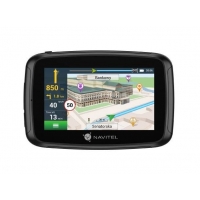
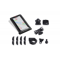
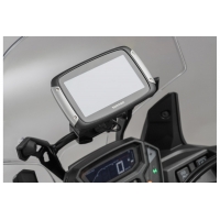
The multipurpose motorcycle navigator
NAVITEL G590 MOTO is based on the reliable Linux OS with an extended list of pre-installed maps that provide great navigation performance on the roads of home country and other countries.

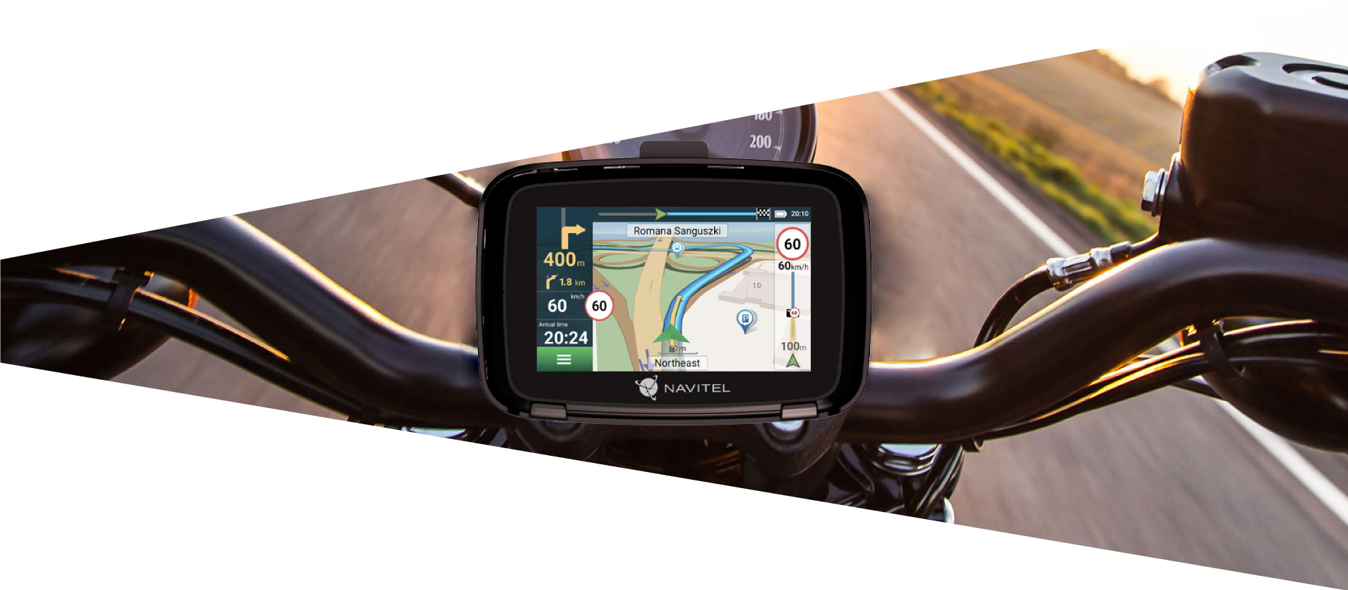
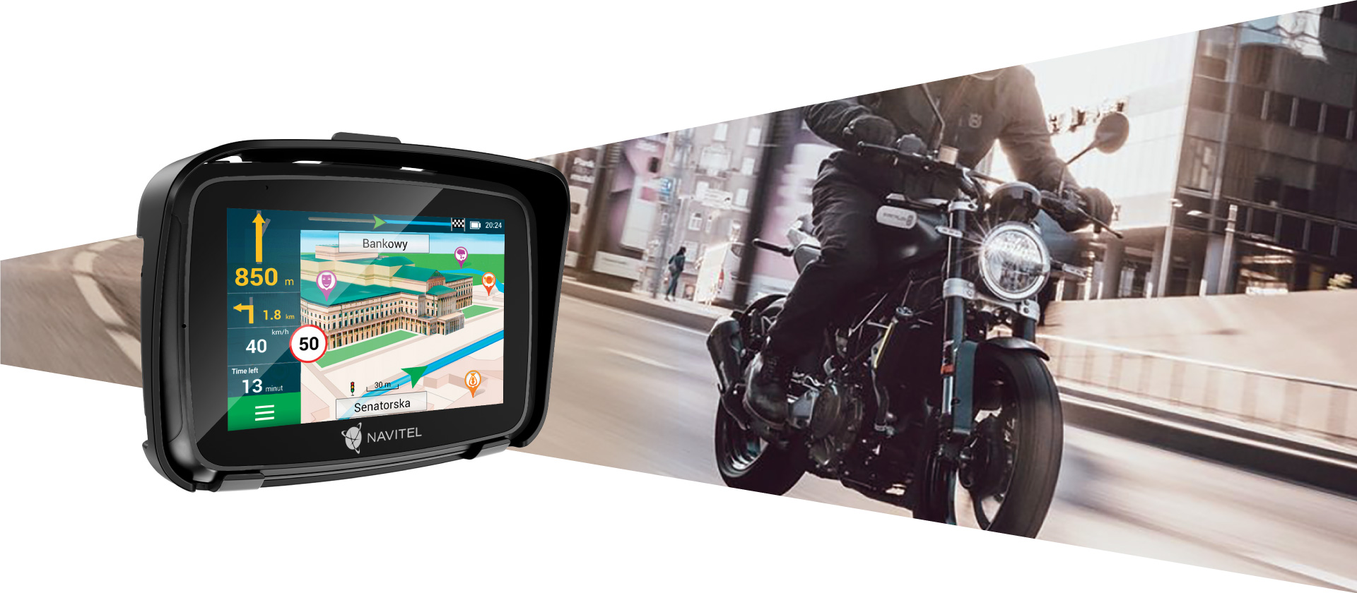
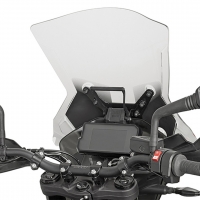
The best solution for motorcycles
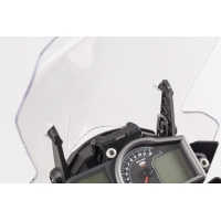
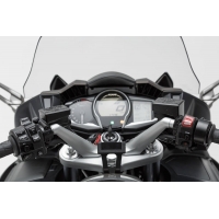
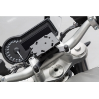
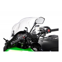
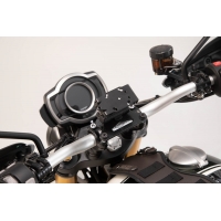
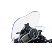
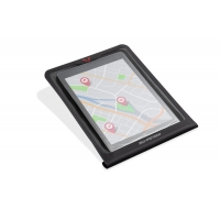
The navigator is equipped with a bright 5” capacitive touchscreen that is easy to read even in sunny weather. The NAVITEL G590 MOTO boasts a user-friendly interface and a bundled finger sleeve that provide convenient and fast device operation. IP66 dust and water protection complemented by a shock-resistant housing provide perfect device usability in any weather, whereas a special mount allows to securely fit the device on the handlebars. The navigator is directly connected to the 12V motorcycle battery, while its 2800 mAh built-in cell provides additional autonomy.
Precise and reliable navigation
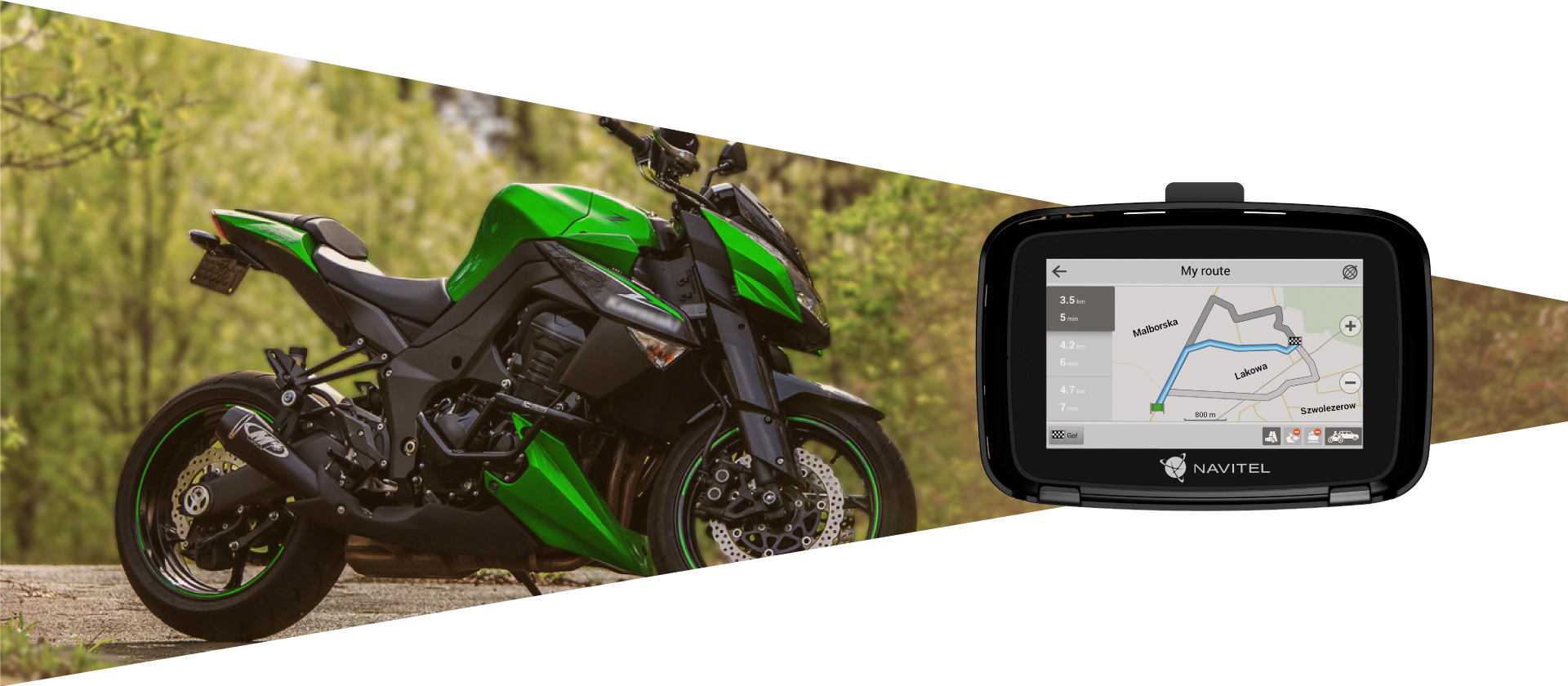
The pre-installed map package allows to use the NAVITEL G590 MOTO without any internet connection. The device not only rapidly calculates routes, but also informs its user about speed limits, traffic cameras* and other obstacles whenever they are getting closer. In addition, the device notifies the driver of exceeding the speed limit for extra safety.
*Traffic camera warnings are disabled for countries where their detection is prohibited by local law.
Offline maps
The package includes a license for maps of European, Asian, and South Caucasian countries with some of them pre-installed on the device. The Navitel Navigator Update Center program allows you to quickly manage their list by deleting, downloading, and updating maps in accordance with your needs. A microSD card of up to 64 GB* of storage may be required to store files and enable some functions like trip track recording.
*Sold separately
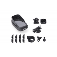
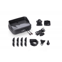
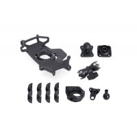
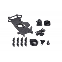
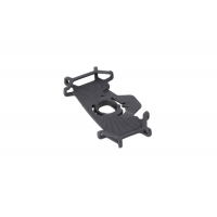
- NAVITEL G590 MOTO navigation device
- Motorcycle charger adapter
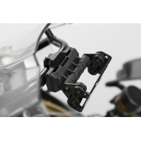
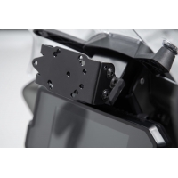
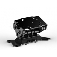
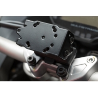
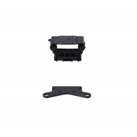
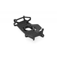
- Active cradle
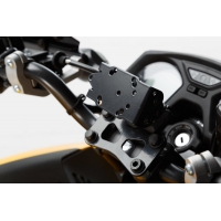
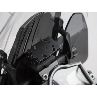
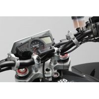
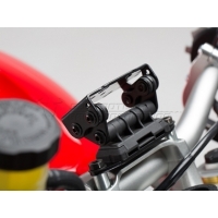
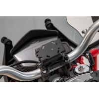
- Motorcycle mount
- USB-A adapter for waterproof connector
- USB to USB-C cable
- Mounting set
- Finger sleeve for touchscreens
- User Manual
- Warranty card
Maps
Every map includes residential and industrial infrastructure with address search and detailed road network with traffic direction, interchanges, roundabouts, and other relevant information. There is also a huge POI database (filling stations, ATMs, restaurants, etc.) and an extensive SPEEDCAM database.
Albania - Andorra - Austria - Belarus - Belgium - Bulgaria - Bosnia and Herzegovina - Cyprus - Czech Republic - Croatia - Denmark - Estonia - Finland - France - Germany - Gibraltar - Greece - Hungary - Iceland - Isle of Man Italy - Kazakhstan - Latvia - Liechtenstein - Lithuania - Luxembourg - North - Malta - Moldova - Monaco - Montenegro - Netherlands - Norway - Poland - Portugal - Romania - Russia - San Marino - Serbia - Slovakia - Slovenia - Spain - Sweden - Switzerland - Ukraine - United Kingdom - Vatican
Documentation
Note: the package, appearance, specifications that do not change the overall functionality of the device may be changed by the manufacturer without prior notice.
Note: the package, appearance, specifications that do not change the overall functionality of the device may be changed by the manufacturer without prior notice.
other products in the same category: (30)
-
UNIWERSALNY ZESTAW RÓŻNYCH UCHWYTÓW GPS Z POKROWCEM NA...
-
UNIWERSALNY ZESTAW RÓŻNYCH UCHWYTÓW GPS Z POKROWCEM NA...
-
UNIWERSALNY ZESTAW RÓŻNYCH UCHWYTÓW GPS Z UCHWYTEM T-LOCK...
-
ZESTAW UCHWYTÓW GPS NA KIEROWNICĘ WRAZ Z POKROWCEM NA...
-
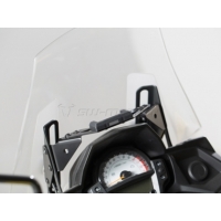
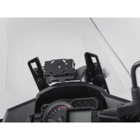
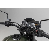
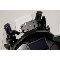
MOCOWANIE GPS NA KIEROWNICĘ SW-MOTECH BMW/HONDA/SUZUKI...
-
MOCOWANIE GPS NA POPRZECZKĘ SW-MOTECH 10/12MM BLACK
-
MOCOWANIE GPS NA POPRZECZKĘ SW-MOTECH 13/16MM BLACK
-
MOCOWANIE GPS DO KOKPITU SW-MOTECH KTM 790/890 ADV....
-
MOCOWANIE GPS DO KOKPITU SW-MOTECH KTM 1290 SUPER...
-
MOCOWANIE GPS DO KOKPITU SW-MOTECH KTM 1050/1090/1190...
-
MOCOWANIE GPS NA KIEROWNICĘ SW-MOTECH YAMAHA FJR 1300...
-
UCHWYT GPS ANTYWIBRACYJNY SW-MOTECH BLACK
-
MOCOWANIE GPS NA KIEROWNICĘ SW-MOTECH BMW MODELS BLACK
-
MOCOWANIE GPS NA KIEROWNICĘ SW-MOTECH BMW/TRIUMPH MODELS...
-
MOCOWANIE GPS NA KIEROWNICĘ SW-MOTECH KAWASAKI Z 1000 SX...
-
MOCOWANIE GPS NA KIEROWNICĘ SW-MOTECH KAWASAKI GTR 1400...
-
MOCOWANIE GPS DO KOKPITU SW-MOTECH KAWASAKI VERSYS 650...
-
MOCOWANIE GPS DO KOKPITU SW-MOTECH KAWASAKI VERSYS 1000...
-
MOCOWANIE GPS DO KOKPITU SW-MOTECH KAWASAKI...
-
MOCOWANIE GPS DO KOKPITU SW-MOTECH KAWASAKI VERSYS 1000...
-
MOCOWANIE GPS NA KIEROWNICĘ SW-MOTECH...
-
MOCOWANIE GPS DO KOKPITU SW-MOTECH TRIUMPH TIGER 800/800...
-
MOCOWANIE GPS NA KIEROWNICĘ SW-MOTECH MOTO GUZZI V85 TT...
-
MOCOWANIE GPS NA KIEROWNICĘ SW-MOTECH DUCATI MULTISTRADA...
-
MOCOWANIE GPS NA KIEROWNICĘ SW-MOTECH DUCATI MULTISTRADA...
-
UCHWYT T-LOCK DO MOCOWANIA SMARTFONA MAŁY SW-MOTECH WITH...
-
POKROWIEC NA TABLET DO TANKBAGU PRO SW-MOTECH MOLLE...
-
UNIWERSALNY ZESTAW RÓŻNYCH UCHWYTÓW GPS Z UCHWYTEM T-LOCK...
-
UCHWYT T-LOCK DO MOCOWANIA SMARTFONA DUŻY SW-MOTECH WITH...
-
KAPPA POPRZECZKA DO ZAMONTOWANIA TOREB I MOCOWAŃ GPS /...